originally published May 5, 2013
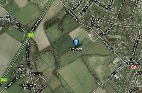
Welcome to beautiful sunny Argleton! While this gorgeous English village won’t appear in many tourist guide books, you’ll nevertheless be impressed by its stunning… minimalism. In fact, Argleton is so profoundly minimalist, one could say it doesn’t actually exist. But it must, right? I mean, it shows up on Google Maps, so how could the place not be there?
But it’s not. If you followed the trail on Google through West Lancashire, slightly northeast of the civil parish of Aughton, you’d find that Argleton is a visual disappointment. All you’ll have to show for your journey is this:
This is because Argleton is in fact nothing more than a strange glitch in the lore of Google mappery. Head of Edge Hill University’s web services Mike Nolan first caught this anomaly in 2008, which piqued a modicum of media interest in the non-existent town. It became a running Twitter punchline, and even sparked the creation of an Argleton website, complete with an extensive town history, upcoming events, and a 6-day travel guide to the area.
Argleton may have been a simple mistake, either by Google or by Tele Atlas, the company that supplies Google with their map information. It may have been a common metasyntactic variable, a placeholder used by the computer program that powers the map. It could be a typo as well, a misspelling of ‘Aughton’, which is right next to it on the map. It’s also quiet likely that Argleton is a paper town.
Paper towns are copyright traps, slipped onto maps by map-makers to catch people who swipe the data for their own uses. You could look for a clue in the name’s anagrams: ‘Not Large’, or ‘Not Real G’, in which the ‘G’ could stand for ‘Google’, or perhaps as a generic nickname in hip-hop-speak (which is somewhat less likely). Whatever its secret history, it’s probably the only paper town that has its own t-shirts.
Argleton – which was yanked off Google in 2010 – is not the first recorded case of locale invention. The official 1978-1979 Michigan State map included two fictional towns, both located across the border in Ohio. Further removed from the Argleston phenomenon, these two towns – Goblu and Beatosu – come with a distinct origin story.
Peter Fletcher, a proud graduate of the University of Michigan, was the chairman of the State Highway Commission. A buddy of his was teasing him about the colors of the Mackinac Bridge, the third-longest suspension bridge in the world and the crucial link between the upper and lower peninsulas of the state. The bridge was painted green and white, the official colors of Michigan State University.
As a strange act of revenge – since Fletcher could not legally order the entire bridge to be repainted – he did this:
Fletcher ordered a cartographer to insert two fake towns onto the periphery of the official state map. Goblu represented the University of Michigan (Go Blue!), and Beatosu was a call to arms to defeat his school’s rival, Ohio State University (O.S.U.). I applaud the use of taxpayer money for a good prank.
Going back a little further in map-making history, we have an entry from the 1930’s, tucked away in the Catskill region of New York.
This was another prank, one set into motion by founder Otto G. Lindberg and his assistant, Ernest Alpers, both of the General Drafting Company, one of the big map-makers of the early motoring age of the twentieth century. Designed specifically as a copyright trap, the two men formed an anagram of their initials and created the non-existent town of Algoe, New York, on Route 206 just north of Rockland.
In Algoe’s case, life became inspired by art. Lindberg’s map became the official map of the Standard Oil Company, later Esso/Exxon. This was back in the days when gas stations would hand out free maps to customers, so word of Algoe’s existence had almost become definitive. At some point in the 1950’s, most likely by a local resident who was aware of the map glitch, the Algoe General Store was opened up at the intersection where the map claimed the town should be.
Map-makers Rand McNally started publishing Algoe’s existence as well, and it seemed as though the prank had brought a community to life. The store went out of business though, and by the 1990’s, Algoe had slipped off the geographical record.
It isn’t just map-makers who try to stave off copyright violators by peppering their ‘facts’ with suspicious data. The 1980 edition of the New Grove Dictionary of Music and Musicians added Italian composer Guglielmo Baldini and flautist Dag Henrik Esrum-Hellerup. Both phony names were yanked from subsequent printings.
At the tail end of Rupert Hughes’ Music Lover’s Encyclopedia back in 1903, you’ll find the entry for ‘zzxjoanw’, the Maori word for ‘drum’. It took more than fifty years for someone to point out that the Maori don’t use the letters ‘Z, ‘X’ or ‘J’ in their language, and that the zzxjoanw was actually a hoax.
The New Oxford American Dictionary got called out in 2005 for its fictional word ‘esquivalience’, meaning the willful avoidance of one’s official responsibilities. The dictionary had been made available in electronic form, so this word was the trap-word to catch people who might plagiarize the dictionary as their own.
This is Jakob Maria Mierscheid. Official listings of the members of the German parliament since 1979 include Jakob, despite the fact that he possesses the political handicap of not actually existing. How he came to be is not entirely clear – there’s a rumor that Weimar-era German Social Democrats used to use his name back in the 1920’s to avoid paying restaurant bills.
Jakob has his own official webpage with the German Bundestag, complete with a biography, and a brief run-down of some of Jakob’s most passionate core causes (like “breeding and care of the curled hood pigeon”.) Every so often Jakob issues press releases. When the parliament was moved to Berlin a few years ago, a pedestrian bridge that connected two office buildings over the Spree River was named the Mierscheid Bridge. German government has officially crossed over into the undeniably wacky.
This makes me question my sources. While a few errors have been pointed out to me, I wonder how much of Wikipedian ‘fact’ that I’ve reported on is purely fiction? What if I was wrong about the origin of the polypropylene chair? What if Bobbejaanland doesn’t really exist? What if these places I just wrote about, which don’t exist, actually do?
All of this is just giving me a headache.
